|
Архитектура Аудит Военная наука Иностранные языки Медицина Металлургия Метрология Образование Политология Производство Психология Стандартизация Технологии |
|
|
Архитектура Аудит Военная наука Иностранные языки Медицина Металлургия Метрология Образование Политология Производство Психология Стандартизация Технологии |
Where ECDIS is primary means, navigational watch keeping hand over must address important information exchange including control of safety settings, alarm settings, rest hours compliance etc.
Bridge team communication on reporting of navigational status as derived from ECDIS must be effective to ensure high standards situational awareness is maintained. Junior Officers are encouraged to intervene and challenge ECDIS passage plans and navigational decision making.
Master’s standing/night orders should reflect his requirement for use of ECDIS as “primary” or “secondary” means of navigation or when used for training purposes only. Example: level of authority for control of safety parameters and alarm settings including alarm interrogation, position fix cross checking to avoid over reliance.
Where ECDIS is the primary or secondary means of navigation, Master/Pilot information exchange procedure must ensure that ECDIS passage plan including safety parameters and alarm settings are discussed with pilots. Cross referencing safety settings on Pilot’s version of ECDIS (referred as PPU’s – Portable Pilot Units) and ship’s ECDIS should be a part of the onboard risk assessment.
ECDIS safety
Navigating Officers must take precautions to make sure they are not only getting accurate information from their ECDIS, but are also prepared for any unforeseen difficulties which may arise. The following safety precautions should always be followed:
• The ECDIS must always have an appropriate back-up system • Never try to remove information from the ENC database
The accuracy of vessel's position, as displayed on the ECDIS screen, must not be considered to be exactly correct. Some systems claim an accuracy of position to within 20m. This can mean that the true position of the vessel may actually be more than 20m away from that shown on the ECDIS screen. Such a margin of error can have serious consequences. Never accept the displayed position as being always completely accurate. Only believe what can be visually observed from the bridge. The quality of information deteriorates when relying on less sensitive sensors.
For example, when you switch from DGPS to GPS the accuracy of the vessel's indicated position can possibly fall from being within 10m to perhaps anywhere between 20m to 100m. Be aware of these changing circumstances calculated values such as ETA at the next waypoint depend on the accuracy of the sensors. Never believe entirely in their accuracy unless you have made visual checks and calculations to confirm them.
If your vessel's ECDIS switches to using unofficial electronic charts for some reason, rather than using official charts, then all the navigational watch keepers must be made aware of this. If this change of charts has not already been previously included in the passage planning notes then the vessel's Master must also be notified as the ECDIS has, by switching to unofficial charts, become unfit for use for primary navigational purposes. Whenever possible, use another independent means of position fixing to confirm the data provided by the primary system after you have finished using whatever items of extra information or other displays you bring up on the ECDIS screen, always return the screen back to the Standard Display showing the vessel's present position. This should be the chart always on routine view be cautious about adding too much extra information to the ENC image on display - an operator can suffer from information overload, and too much information on the display screen may obscure a navigation problem which is developing.
In coastal waters visual bearings and radar distances must be used to verify the position obtained from ECDIS. Record of vessel’s position during the voyage must be retained so that it is possible to re- create the track followed, if required, at a later date. 1.10 Safety settings:
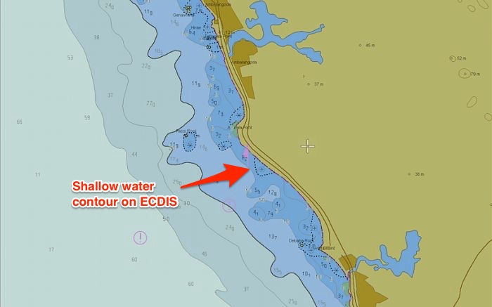
1.10.1 Shallow Contour setting A contour is a line separating a minimum depth area. For example, a 10 meter contour will be a line that separates waters below and above 10 meters depths. The contours are in the value of 5, 10, 15, 20, 30 and so on. Shallow contour value need to be used to tell ECDIS what is the value of shallow waters for our draft. This is the value of depth below which it is definite for the vessel to get aground. The shallow contour value need to be equal to or more than the draft of the vessel. Let us say the vessel’s draft is 9 meters and we enter the shallow contour value of 9 meter. The ECDIS will display 10meter contour line as the shallow contour. If 10meter contour is not available, it will take next contour as the shallow contour for the vessel. The shallow contour lets the navigator know that between 0meter depth and the shallow contour, the area is not navigable at all.
Safety Contour setting Safety contour is the contour line beyond which we can navigate without any water depth concern. This is the depth that takes into account the Draft, required UKC, Squat, CATZOC, and the Dynamic and draft components. This calculated value will be the Safety contour. The safety contour provides a visible boundary between “safe” and “unsafe” water with respect to depth, and is highlighted on the display to enable easy identification.
The Safety contour setting is made by the navigator after taking into account: Ø Ship’s draught Ø Under Keel clearance requirement (as per UKC Policy) Ø Squat Ø CATZOC Ø Dynamic components: · Tide allowance · Dock water allowance (DWA) / Fresh water allowance (FWA) · Wave height Ø Draft components: · Heel correction · Rolling allowance However, ECDIS will choose the next higher contour as the safety contour if this depth value is not available. If, for instance, the safety depth is 11 m and the safety contour is also set to 11 m the ECDIS will display the next available safety contour of the ENC in use. If the safety contours of the ENC are set in 5 meter the safety contour displayed on the chart will be the 15 m contour. Safety Depth setting Safety depth is the only depth setting on ECDIS. Safety depth is the depth of the water we can safely navigate upon. It is the depth that satisfies the UKC policy. In ECDIS we need to enter this minimum depth. It is same what was calculated in safety contour setting. But the question is why do we need safety depth settings when we can navigate in waters above the safety contours? This is because of two straight forward reasons |
Последнее изменение этой страницы: 2019-03-22; Просмотров: 719; Нарушение авторского права страницы