|
Архитектура Аудит Военная наука Иностранные языки Медицина Металлургия Метрология Образование Политология Производство Психология Стандартизация Технологии |
|
|
Архитектура Аудит Военная наука Иностранные языки Медицина Металлургия Метрология Образование Политология Производство Психология Стандартизация Технологии |
UNIT 9 – EARTH RESOURCES EXPLORATION
Human societies have become increasingly dependent for their well-being on the ability to collect and analyse information. The world is becoming more crowded and resources are becoming more scarce. Modern industry uses ever greater quantities of almost all minerals in the earth’s crust. It is not possible to make best use of the land and natural wealth without good factual knowledge, without accurate information about lands and waters, and without an up-to-date inventory of a country’s resources and what is happening to the environment. Over the past decades it has become increasingly apparent that, the effects of human activities are becoming more pervasive, and recognition and prediction of causes and effects more complex. Space technology is widely applied practically throughout the whole world to help specialists analyse information about the Earth and its environment. The advantage of collecting information about landscape from a distance was recognized long ago. The methods of using photographs to make accurate measurements developed into the field of Photogrammetry. Cameras and their use for aerial photography are the simplest and oldest of sensors used for remote sensing of the Earth’s surface. Cameras are framing systems 1 which acquire a near-instantaneous “snapshot”2 of an area of the surface. Today most natural resources mapping is done using remote sensing. With the development of remote sensing technology it is now possible to collect geographic information on a global basis. Remote Sensing is the technique of collecting information about objects or phenomena from a distance, i.e. without being in physical contact with them. It was the introduction of earth resources satellites that made remotely sensed data3 readily available to all. Satellite-based systems can now measure phenomena that change continuously over time and cover large, often inaccessible areas. Remote sensing is a highly sophisticated technology and is now being used as a valuable cost-effective means4 of acquiring information about earth resources. Basically a means of rapidly surveying the Earth’s environment from a distance, remote sensing techniques generally involve using aircrafts or satellites with sensors operating in the electromagnetic spectrum. As a satellite revolves around the Earth, the sensor “sees” a certain portion of the Earth’s surface. Earth orbiting satellites or an aircraft carry a variety of remote sensing equipment: metric cameras for precision photographic infrared band as well as special digital multispectral scanners (MSS)5. Each satellite MSS scene covers about 200 × 200 km of the Earth’s surface. There are four spectral bands in a MSS scene, each containing about 7 million pixels, so all four MSS bands combined have about 30 million pixels (a pixel is the smallest picture element covering a ground area of about 56 × 80 m) and each pixel can have as many as about 128 possible shades of gray. By analysing these bands similar land types6 can be extrapolated from the entire image thus producing a classification of the scene. Three television cameras and a multispectral scanner (an optical device that records images by breaking a scene into many tiny segments) simultaneously photograph about a 200 square kilometer section of the earth’s surface in seven light bands (reds, greens and infrared). Each of the light bands identifies specific feature of water, land and vegetation. These seven spectral bands contain more than 200 million pixels. Coupled with improved processing equipments7 and greater experience these vast amounts of data are yielding more and more information about the Earth and its resources. Each band may be processed, enhanced, or combined in a wide variety of ways. Images are relayed to ground stations and processed. The MSS system for the first time provided digital images suitable for computer analysis for most of the earth’s surface. The data in both digital and photographic images are used operationally in variety of time-critical and large area applications8. To provide complete coverage of large areas at regular intervals, satellite-based remote sensing systems are the only practical data collection method. Earth resources satellites data are used for reconnaissance of minerals, petroleum (oil) and gas exploration. Many important mineral deposits are not exposed at the earth’s surface. To locate them, it is necessary to infer their presence. The analysis of the geology of a region is fundamentally a data integration procedure. To be of use all the obtained data must be analysed with reference to their geographical location9. By studying the known ore deposits or some other minerals geologists for example are able to define a set of characteristics that might be used to indicate the presence of other deposits in the region. Some satellites carry a sensor called the Advanced Very High Resolution Radiometer (AVHRR). In agriculture its image data are used to estimate the area planted to important food crops and the condition of the crops through the growing season. Land use and weather data provided from earth resources satellites and field measurements as well as production information from previous years are analysed together to compare current production levels with past years crop condition and predict for each region the expected yield of one or more crops. Forestry encompasses the management of a wide range of natural resources that occur in forest areas. In addition to timber, forests provide such resources as grazing land, land for livestock, recreation areas, wildlife habitat, and water supply sources. Satellite-based earth observation provides timely, accurate, and affordable data on the quality and quantity of forest resources, because the forest inventory is the primary management tool not only for timber production but for the environment. It is used to assess the existing forest resource and to project future timber supplies, and for other operational planning activities. Information like species composition, age, tree size, density, structure and condition is derived from the airphotos and supporting field data. The basis forest unit is the stand. Historical information, pertaining to each stand, such as harvesting, regeneration, road building, or forest damage, is also very important. In forestry earth orbiting satellites data have been used to estimate forest losses caused by fires, clearcutting and disease. Satellite data are widely used for land use planning. Current land cover, the detection of changes in land use over time, and route location planning are common applications. Very detailed photographs taken from aircraft are useful for many applications where identification of detail or small target is required, e.g. city maps. Municipalities have even used airphotos to identify unrecorded property improvements. The earth’s weather systems10, vegetation and ocean circulation are monitored on a daily basis using satellites that produce digital images and digital measurements. Weather satellites provide temperature measurements at the earth’s surface and at different altitudes above the surface. Analyses of such data provide valuable predictions of climate trends, that can be used for long range planning. Information from satellites aids an air and sea navigation, weather forecasting and oceanographic studies. The oceans are an important natural resource that are difficult to map and monitor over large areas or for extended periods of time. Satellite data are also used extensively to estimate sediment content and chlorophyll concentrations; phytoplankton and pollution in marine and fresh-water environments and to map water depths, the position of currents and areas of upwelling, important for managing fisheries. Earth resource satellites data have been used to monitor rangeland condition, wildlife habitat, and to aid in the assessment of damage caused by natural disasters, to monitor snow coverage, assess snow depths, and melting conditions, monitor floods, detect and map forest fires, monitor dust and sand forms, identify geologic events like volcanic eruptions and assessment of typhoon damage.
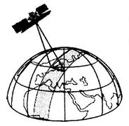
The sensor “sees” a certain position of the Earth’s surface
Re-inventory using aerial photographs is usually done on a 10-year cycle. Maps are updated practically annually.
Notes:
Exercises
Ex. 1. Pronounce correctly: geology, geologist, geodesy, geography, geographic; general, generally, image, digital; refer, reference, with reference to; air, aircraft, airspace, airphotos, area, areas, aerial, aid; date, dates, update, updated; datum, data, image data; weather data sense, sensed, sensing, remote sensing, remote sensing equipment; process, processes, processed, data processing, processing equipment; earth, earth’s surface, earth’s crust, earth orbiting satellites, earth resources; source, resource, country’s resources, water supply resources, natural resources; regeneration, age, large, range, rangeland, vegetation, coverage, damage, region; Ex. 2. Translate the word combinations with nouns in the function of an attribute: earth resources exploration; space technology; land and natural wealth; remote sensing equipment; earth resources satellites; satellite data; image data; satellite-based systems; field measurements; production information; timber production; water resources; satellite-based earth observation; basis forest unit; land use; route location planning; city maps, property improvements; the earth’s weather systems; temperature measurements; climate trends; air and sea navigation; weather forecasting and oceanographic studies; sediment content; chlorophyll concentrations; fresh-water environments; water depths; snow depths; wildlife habitat; rangeland condition; dust and sand forms; volcanic eruptions and assessment of typhoon damage. |
Последнее изменение этой страницы: 2017-05-06; Просмотров: 651; Нарушение авторского права страницы