|
Архитектура Аудит Военная наука Иностранные языки Медицина Металлургия Метрология Образование Политология Производство Психология Стандартизация Технологии |
|
|
Архитектура Аудит Военная наука Иностранные языки Медицина Металлургия Метрология Образование Политология Производство Психология Стандартизация Технологии |
UNIT 5 – GEODESY AS A CAREER
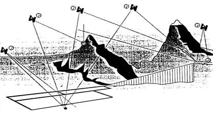
There are many different types of careers that fall into the category of environmental sciences. Geodesy is one of them. Geodesy is the scientific discipline that deals with the measurement and representation of the Earth, including its gravitational field, in a three-dimensional time-varying space1 as well as with location of fixed points on the Earth. At one time, all work done in the field of geodesy was based on land surveys. Now, land surveys are done in conjunction with the use of satellites. Surveying or land surveying is the technique and science of accurately determining the terrestrial or three-dimensional space position of points and the distances and angles between them. These points are usually associated with positions on the surface of the Earth, and are often used to establish land maps and boundaries for ownership or governmental purposes. In order to accomplish their objective, surveyors use elements of geometry, engineering, trigonometry, mathematics, physics, and law. Furthermore, a particular type of surveying known as " land surveying" is the detailed study or inspection, as by gathering information through observations, measurements in the field, research of legal instruments2, and data analysis in the support of planning, designing, and establishing of property boundaries. It involves the re-establishment of cadastral surveys and land boundaries based on documents of record and historical evidence, judicial surveys, and space delineation3. Land surveying can include associated services4 such as mapping and related data accumulation, construction layout surveys5, precision measurements of length, angle, elevation, area, and volume, as well as horizontal and vertical control surveys6, and the analysis and utilization of land survey data. Surveying has been an essential element in the development of the human environment since the beginning of recorded history (ca. 5000 years ago) and it is a requirement in the planning and execution of nearly every form of construction. Its most familiar modern uses are in the fields of transport, building and construction, communications, mapping, and the definition of legal boundaries for land ownership. Surveying equipment. As late as the 1990s the basic tools used in planar surveying7 were a tape measure for determining shorter distances, a level for determining height or elevation differences, and a theodolite, set on a tripod, with which one can measure angles (horizontal and vertical), combined with triangulation. Starting from a position with known location and elevation, the distance and angles to the unknown point are measured. Electronic distance-measuring devices had made field surveys easier and more accurate, while much improved circle graduation has made theodolites (transists) lighter as well as more precise. A more modern instrument is a total station, which is a theodolite with an electronic distance measurement device (EDM) and can also be used for leveling when set to the horizontal plane. Since their introduction, total stations have made the technological shift from being optical-mechanical devices to being fully electronic with an onboard computer and software. Modern top-of-the-line total stations8 are fully robotic, and can even e-mail point data to the office computer and connect to satellite positioning systems, such as a Global Positioning System (GPS), a device used to help define a location and map it in relation to other spots on the planet. This is something that can be quite useful to geodesists who use GPS in their field of work. With the use of a GPS device, geodesists can locate the exact position of any object on the surface of Earth which gives them valuable information without the need to physically travel to locate or chart specific things. Though real-time kinematic GPS systems have increased the speed of surveying, they are still only horizontally accurate to about 20mm and vertically accurate to about 30-40mm. However, GPS systems do not work well in areas with dense tree cover or constructions. Total stations are still used widely, along with other types of surveying instruments. One-person robotic-guided total stations9 allow surveyors to gather precise measurements without extra workers to look through and turn the telescope or record data. A faster way to measure large areas (not details, and no obstacles) is with a helicopter, equipped with a laser scanner, combined with a GPS to determine the position and elevation of the helicopter. To increase precision, beacons are placed on the ground (about 20km apart). This method reaches precisions between 5-40cm (depending on the flight height).
Satellite navigation Surveying as a career. The basic principles of surveying have changed little over the ages, but the tools used by surveyors have evolved tremendously. Engineering, especially civil engineering, depends heavily on surveyors. Whenever there are roads, railways, reservoir, dams, bridges or residential areas to be built, surveyors are involved. They establish the boundaries of legal descriptions and the boundaries of various lines of political divisions. They also provide advice and data for geographical information systems (GIS), computer databases that contain data on land features10 and boundaries. A geographic information system (GIS) is any system that captures, stores, analyzes, manages, and presents data that are linked to location. In the simplest terms, GIS is the merging of cartography and database technology. GIS systems are used in cartography, remote sensing, land surveying, photogrammetry, geography, urban planning, emergency management11, navigation, and localized search engines12. In the strictest sense, the term describes any information system that integrates, stores, edits, analyzes, shares, and displays geographic information. In a more generic sense, GIS applications are tools that allow users to create interactive queries (user-created searches)13, analyze spatial information, edit data, maps, and present the results of all these operations. Surveyors must have a thorough knowledge of algebra, basic calculus, geometry, and trigonometry. They must also know the laws that deal with surveys, property, and contracts. In addition, they must be able to use delicate instruments with accuracy and precision14. What does a geodesist do? A geodesist measures the Earth's surface. He studies the science and shape of our planet as well as its gravitational field. A geodesist measures the size of the Earth on a global scale and also specific regions of land known as fixed points. By doing so, crustal shifts and polar movement can be detected. Measurements can determine rate of movement and other pertinent information. A geodesist assigns 3 dimensional points on, above and below the surface of the Earth to measure the average depths of oceans, mountain peaks and also abnormalities in the surface of the Earth. The field of geodesy also includes the study of tides as well as crustal and polar motion15. The field of geodesy developed from the human need to understand the world in which we live. As it was once believed that our world was flat, we now know much more about our planet through specialized fields such as geodesy.
Notes:
Exercises Ex.1. Pronounce correctly: angle, triangle, triangulation, tripod; apply, applicable, application; survey, surveying, surveyor; technique, technical, technology; space, spatial; observe, observation, observer, observatory; precise, precision; geodesy, geodetic, geodesist; determine, determination; local, locate, location; theory, theoretical, theoretician, theodolite; satellite; Earth, Earth’s surface, engine, engineer, engineering; sense, sensing, remote sensing
Ex.2. Find English equivalents in the text: трёхмерное пространственное положение; использование данных съёмки; местоположение точек на земной поверхности; разность высот; землевладение; густо растущие деревья; редактирование данных; поверхность Земли; гравитационное поле; в глобальном масштабе; путём наблюдений Ex.3. Complete the sentences: 1. Geodesy is a science that deals with …. 2. Nowadays land surveys are done in conjunction with … 3. … is a technique of determining the position of points and distances and angles between them. 4. A level is used for determining … 5. … is a theodolite with EDM. 6. GPS stands for … 7. With the use of … geodesists can locate the exact position of any object on the surface of the Earth. 8. … are involved whenever there are roads, railways and dams.
Ex.4. Answer the questions: 1. What is geodesy? 2. What was all work in geodesy based on in the past? 3. What is surveying? 4. What sciences should surveyors be good at to accomplish their objective? 5. In what fields is surveying most frequently used nowadays? 6. What are the traditional surveying instruments? 7. How are short distances measured? 8. What instrument measures height or elevation difference? 9. How do surveyors measure angles? 10. What modern instrument is used instead of the theodolite? 11. What is GPS? 12. What kind of information does GIS contain? 13. What do geodesists do?
Ex.5 Translate into English: 1. Геодезия – это наука, которая изучает размер и форму Земли. 2. Съёмка включает методы точного определения пространственного положения точек на земле, а также расстояний и углов между ними. 3. Наиболее распространёнными сферами применения съёмки являются транспорт, строительство, связь, картография и определение границ. 4. Классические геодезические инструменты – это мерная лента, уровень и теодолит. 5. Более современным геодезическим инструментом является электронный тахеометр. 6. Система глобального позиционирования помогает определять местоположение (координаты) точки (пункта) и её положение относительно других пунктов на Земле. 7. ГИС – информационная система, которая хранит, анализирует и представляет данные о местоположении объекта (т.е. геопространственную информацию). 8. Геодезисты изучают форму Земли и её гравитационное поле.
Ex.6. Translate into Russian: Knowledge required by the position of a geodesist. Expert knowledge of the theories, principles, and practices in theoretical geodesy and the ability to apply this knowledge to the solution of major problems which are constantly arising as new satellite technology progresses and geodetic practices enter new and more complex areas. The geodesist must have a working knowledge of computer technology as it applies to geodesy; to effectively apply mathematical techniques regarding large blocks of data. This involves the control languages of many computers, the data filing systems of direct-access devices, as well as the master data base storage media, and the programming languages applicable to mathematical geodesy. He must be able to communicate on a professional level with other members of the surveying and geodetic community to effectively represent the organization at local, national, and international meetings to explain geodesy and to take an active part in scientific and mapping organizations. UNIT 6 – CADASTRE
In both the private and public sectors, land information is a primary resource for making investment and management decisions. Those who have access to land information have an additional capacity to evaluate situations, to analyze past conditions and to plan for the future. A land Information System(LIS) is a special type of GIS, that is designed to handle detailed land ownership information. The cadastre is normally a parcel-based and an up-to-date information, and a subset of LIS that has been defined as a record of interests in land, encompassing both the nature and the extent of these interests1. The cadastre is an official, public record in which complete, up-to-date information for all parcels within a given geographical region is maintained. A cadastre is a comprehensive register of the real property of a country and commonly includes details of ownership, the tenure, the precise location (some can include GPS coordinates), the dimensions (and area), the cultivation if rural and the value of individual parcels of land. The cadastral parcel is a continuous area or volume of land2 in which unique, homogeneous interests or rights are recognized. The need for cadastral information is common to all societies. Parcel-based information3 is required in a wide variety of activities and frequent users range from the individual landowner (current or prospective), to lawyers, surveyors, real estate managers, and agencies at all levels of government. The cadastre consists of three basic components: – the cadastral parcel as the basic unit for organizing information in the system; – cadastral record(s) which may contain both textual and graphical information; – parcel identifiers or index codes, that serve as the primary spatial reference4 for information. The creation (зд. определение участка) of the parcel also requires specification of boundaries. A boundary is defined as a separation, natural or artificial, that delimits the extent of the parcel and distinguishes it from all other parcels. The Cadastre often describes the value of the parcel and its improvements5. There are three categories of cadastres: – fiscal cadastres developed primarily for property valuation and equitable taxation; – juridical cadastres which serve as a legally recognized record of land tenure; – multipurpose cadastres that can encompass both fiscal and juridical cadastres and contain a variety of other parcel-related land information. The multipurpose cadastre offers several improvements6 of a traditional parcel-based systems, including: – the provision of a geodetic spatial reference system7 and large-scale mapping which have wide economic and social benefits; – the coordination (зд. упорядочение) of existing fiscal and juridical records to reduce duplication and to provide an improved information base (e.g., completeness and reliability of records, indexing and graphical display) for both property assessment and land registration; – linkage mechanisms to allow integration of cadastral information with information in other LIS and GIS for planning and resource management. Cadastres are parcel-based land information systems that manage information about the land, its use, and its ownership at the parcel level to support administrative functions. All land administrative functions depend on this information. This figure illustrates the relationship of cadastral systems to land tenure and resource management.
The relationship of cadastral systems to land tenure and resource management Land Cadastre encompasses such information as land resource capacity8, land tenure, land ownership and different land uses. The Cadastre provides: – information identifying those people who have interests in parcels of land; – information about those interests, e.g. duration of land rights, restrictions and responsibilities; – information about the parcel, e.g. location, size, improvement, value. Land tenure is concerned with the rights, restrictions and responsibilities that people have with respect to the land. The Cadastre may record different forms of land tenure such as ownership, leasehold, easements and mortgages. Urban cadastre is a physical description of the land and real estate tenure in a city. It contains graphic and textual information. Graphic information includes the description of each individual parcel and building, topographic features such as roads, rivers, contour lines, additional information such as cartographic grids, geodetic benchmarks, etc. Textual information includes names of owners or occupants, names of streets or areas of specific interest, main characteristics of each parcel or building such as the area, the fiscal value, the associated certificates9, etc. Both types of information are linked together and managed in a system known as a cadastral information system. Most of the time, the cadastre is integrated with the property registry, the legal registration of land and real estate property. Integration of the cadastre with the registry creates a parcel-based registry or a legal cadastre. This guarantees the exact correspondence between physical and legal ownership. In other words, wherever there is a parcel or building, there are the corresponding titles or “legal tenure documents” registered in the property registry, and respectively, wherever there are registered titles, there is a unique parcel corresponding to it. This is technically permitted by a unique identification number that links the parcel or the building to the title. In different countries the Surveyor undertakes different roles in relation to the establishment and maintenance of the Cadastre. The Surveyor may be responsible for: – cadastral surveying and mapping; – cadastral information recording; – land valuation; – land use planning; – management of both the graphic and textual cadastral data bases; – resolving land disputes; – custody and supply of cadastral information. Modern technologies, such as up-to-date survey instruments, satellite position fixing (Global Positioning System – GPS), aerial photography and photogrammetry can offer new possibilities to increase the speed and lower the costs for cadastral reform. Computer technologies can usually provide better access to information, better manipulation of cadastral data, better quality, and better legal and physical security. To fully utilize modern technologies it is important to have trained personnel and facilities to maintain the equipment.
Notes:
Exercises Ex.1. Pronounce correctly : cadastre, cadastral, cadastral survey; surveying, surveyor; restriction, description, describe, responsible, responsibility; establish, establishment; tax, taxation; tenure; value, valuation, valuable; equitable; convey, conveyancing; environment, environmental; identity, identify, identification; maintain, maintenance; mortgage; ease, easement, easy; lease, leasehold; urban, urbanization; occupy, occupant, occupation.
Ex.2. Find English equivalents in the text : регистрация земельных прав; стоимость участка; устойчивое развитие; защита окружающей среды; увеличить скорость; снизить стоимость; квалифицированный персонал; регистрация собственности; определение местоположения с помощью спутников; идентификационный номер участка; справедливое налогообложение; разные формы землепользования
Ex.3. Complete the sentences: 1. A cadastre is normally a parcel-based …. 2. … enables environmental protection. 3. Land tenure is concerned with the rights, restrictions and responsibilities that people have with respect to …. 4. The surveyor undertakes different roles in relation to … in different countries. 5. Computer technologies provide better access to …. 6. … is a physical description of the land and real estate tenure in a city. 7. Wherever there are registered titles there is ….
Ex.4. Say whether the sentences are true or false: 1. The cadastre doesn’t describe the value of the parcel. 2. Land tenure is concerned with the rights, restrictions and responsibilities that people have to the land. 3. The surveyor is not responsible for cadastral information recording. 4. Textual information includes topographic features. 5. Integration of the cadastre with the registry creates legal cadastre. 6. A unique identification number links the parcel to its value.
Ex.5. Translate into English : 1. Кадастр – это свод сведений о земельных участках, их местоположении, правовом положении и целевом назначении. 2. Кадастр способствует устойчивому развитию и защите окружающей среды. 3. В разных странах геодезисты выполняют разные функции, связанные с кадастром. 4. Благодаря современным технологиям создаются новые возможности для ускорения проведения кадастровых реформ. 5. Городской кадастр даёт описание земли и недвижимости на территории города. 6. Кадастровая информационная система включает в себя графическую и текстовую информацию. 7. Каждый участок земли и каждое здание имеет соответствующий идентификационный номер. 8. Компьютерные технологии облегчают доступ к кадастровой информации. 9. Кадастр имеет дело c регистрацией недвижимости и оформлением прав на неё. Ex.6. Answer the questions: 1. What is cadastre? 2. What are the purposes of cadastre? 3. What kind of information does land cadastre provide? 4. What is land tenure concerned with? 5. What kinds of land tenure are there? 6. What is a surveyor responsible for? 7. What is urban cadastre? 8. What are the two types of information included in urban cadastre? 9. What is cadastre normally integrated with? 10. What kinds of modern technologies are used for cadastral reforms?
Ex.7.Translate the text into Russian: Cadastral surveys are used to document land ownership, by the production of documents, diagrams, sketches, plans (plats in USA), charts, and maps. They were originally used to ensure reliable facts for land valuation and taxation. Napoleon established a comprehensive cadastral system for France which is regarded as the forerunner1 of most modern versions. Cadastral survey information is often a base element in Geographic/Land Information systems used to assess and manage land and built infrastructure. Such systems are also employed on a variety of other tasks, for example, to track long-term changes over time for geological or ecological studies, where land tenure is significant. A cadastral map is a map showing the boundaries and ownership of land parcels. Some cadastral maps show additional details, such as survey district names, unique identifying numbers for parcels, and their respective areas, adjacent street names, selected boundary dimensions and references to prior maps. In most countries legal systems have developed around the original administrative systems and use the cadastre as a means of defining the dimensions and location of land parcels described in legal documentation. This leads to the use of the cadastre as a fundamental source of data in disputes and lawsuits2 between landowners. GIS in cadastre Notes: 1. forerunner – предшественник, предвестник; 2. lawsuit – судебный процесс. |
Последнее изменение этой страницы: 2017-05-06; Просмотров: 2003; Нарушение авторского права страницы