|
Архитектура Аудит Военная наука Иностранные языки Медицина Металлургия Метрология Образование Политология Производство Психология Стандартизация Технологии |
|
|
Архитектура Аудит Военная наука Иностранные языки Медицина Металлургия Метрология Образование Политология Производство Психология Стандартизация Технологии |
For detailed description see ReProject User’s Guide ⇐ ПредыдущаяСтр 6 из 6
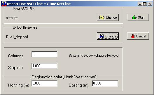
Import of DEM from ASCII file
For orthorectification it is necessary to use DEM in OSD формат. For this purpose it is possible to import DEM from ASCII files. ASCII формат with one height value per a line, lines are separated by < CR> /< LF>. Beginning of output DEM file in OSD формат corresponds to the North-West corner of the area. Therefore, the height values in input ASCII file must start from the North-West corner of the area and be located by lines. The origin point is the North-West corner of DEM. If source ASCII file is recorded starting from the South-West corner, then after import it is possible to use FLIP utility to flip DEM around horizontal axis.
Import of DEM from ASCII file
· ASCII формат with each line containing all height values of DEM in one line. The values are blank separated, lines are separated by < CR> /< LF>. The order of input lines must corrspond to North-to-South direction. The origin point is the North-West corner of DEM.
Import of DEM from ASCII file
* ASCII формат with values X (Easting), Y (Northing), Z (Height) in each line, lines are separated by < CR> /< LF>. X, Y, Z values must be blank separated. X, Y, Z values can be preceded by a point number, in this case it is necessary to specify option " ignore first column". Input file must contain all X, Y, Z values of a regular matrix. Interpolation of missed heights is not performed. If a value is missed, the DEM element is filled with a default value (0).
Export of DEM to ASCII file
If necessary it is possible to export DEM from the interior формат OSD to ASCII file in one of the following форматs: * ASCII формат with one height value per a line, lines are separated by < CR> /< LF>. The hight values in output file are located from the North-West corner by lines.
* ASCII формат with each line containing all height values of DEM in one line. The values are blank separated, lines are separated by < CR> /< LF>. The hight values in output file are located from the North-West corner.
ASCII формат with values N (point number), X (Easting), Y (Northing), Z (Height) in each line, lines are separated by < CR> /< LF>. N X, Y, Z values are separated by comma and blank. The points in output file are located from the South-West corner by lines.
Flip
To flip or rotate source image and DEM files around horizontal axis use " Flip" utility from " Utilities" item of Main Menu.
- no flip, can be used for формат conВерсия, e.g. TIFF to BMP; - flip around vertical axis; - flip around horizontal axis; - rotation 1800; - rotation 900 clockwise; - rotation 900 counterclockwise;
Форматы входных файлов
· Исходные снимки. Исходные снимки могут быть в форматах: TIFF, BMP, JPEG, OSD, ERS, DTM. · Файлы ЦМР. ЦМР может быть в следующих форматах: OSD, ERS, DTM или TIFF 16-bit формат или могут быть импортированы из ASCII формата (смотри " Импорт ЦМР из ASCII файла" IDH_Imp выше).
Формат выходного ортоизображения
Images can be saved in TIFF, BMP, JPEG, OSD(OrthoMap Dataset), ERS форматs. In OSD формат the image or DEM data is stored in BIL формат starting from the upper left corner of image or DEM. Accompanying inформатion (geo inформатion, image size, etc.) is stored in a separate text file (header) with the same name as the data file and extension OSD. The data file name has no extension. For TIFF, BMP and JPEG форматs corresponding geo-referencing file (" world file" ) is automatically created, e.g. TFW for TIF.
Формат of OSD file header
Заголовок OSD файла разделен на следующие блоки: CoordinateSystem. Этот блок содержит следующее:
Эллипсоид (" Datum" ); Картографическая проекция (" Projection" ); Единицы измерения(" Units" ) - метры.
ImageInfo. Блок содержит следующую информацию:
* Тип ячейки (" CellType" ); * X и Y размеры ячейки в " Units" (XDimension, YDimension); * Количество строк (" NrOfLines" ) и колонок (" NrOfCellsPerLine" ) файла данных; * Точка привязки (" RegistrationPoint" ) – геодезические координаты точки привязки в " Units"; * Пиксельные координаты точки привязки в файле (" RegistrationCellX" and " RegistrationCellY" ); * Количество диапазонов (" NrOfBands" ).
Example OrthoSetDataHeader [ Версия = 1.0 LastUpdated = Fri Jun 30 17: 20: 24 GMT 2000 DataSetType = OrthoSetData ByteOrder = LSBFirst CoordinateSystem [ Datum = " PULKOVO" Projection = " GAUSE15" Spheroid = " " Units = " METERS" CoordinateType = EN CoordinateSystem ] ImageInfo [ CellType = UNSIGNED16BITINTEGER Xdimension = 20.000 Ydimension = 20.000 NrOfLines = 250 NrOfCellsPerLine = 250 RegistrationPoint [ Eastings = 6334000.000 Northings = 3324000.000 RegistrationPoint ] RegistrationCellX = 0.000 RegistrationCellY = 0.000 NrOfBands = 1 ImageInfo ] OrthoSetDataHeader ] Формат GCP-файла
GCP-файл (Ground Control Points) формируется любым текстовым редактором. Представляет собой текстовый файл, каждая строка которого содержит информацию об одной контрольной точке в следующем виде: Популярное: |
Последнее изменение этой страницы: 2017-03-09; Просмотров: 471; Нарушение авторского права страницы